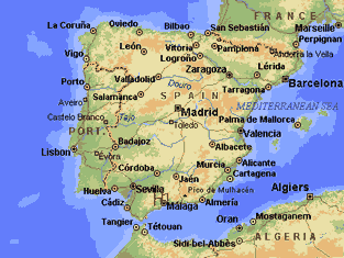
The Spanish State, the second largest country in Western Europe, occupies 85 percent of the lberian Peninsula which it shares with its western neighbour, Portugal. It is cut off from, the rest of Europe by the towering Pyrenees on its French border. On the north and northwest is the Atlantic; its southern and eastern shores front on the Mediterranean. Most of Spain's great interior is occupied by a high and arid plateau, the Meseta, compartmentalized by mountain ranges and river valleys. Only moderately densely populated, Spain is primarily an agricultural country greatly dependent upon irrigation.
 Travel to Málaga
Málaga is the largest city on the beautiful Costa del Sol in Andalusia, along Spain’s southeast coast. It is a relaxed city which is famous around the world for its fantastic beach resorts, sunshine and Mediterranean climate. It is the birthplace of Picasso and features fantastic museums, history and outdoor activities.It is also the transport hub for southern Spain, so tourists to the Costa del Sol will find it well connected; best of all, flights to Málaga only take between two and three hours from the UK.
Málaga is reachable by air from Málaga airport (AGP), one of the biggest in Spain, which is popular with budget airlines. Flights depart here for over one hundred cities in Europe and around the world.
Pick up your hire car at the airport, or take a cab into town for €15-20. Tourists can catch the bus into the city centre for just €1.10, which takes about half an hour.
Málaga’s excellent train station, María Zambrano, is served by high-speed AVE trains; these connect the city to Madrid in just two tothree hours, and also serve Seville and Cordoba. It is possible to connect to other high speed trains in Madrid which head north to Barcelona and France. Slower trains head to Granada, and local commuter trains connect tourist towns along the coast; busses depart from the station across the street for other tourist towns in the area.
If driving, take the N-340 or Autovía A-7 east along the Costa del Sol, then north to Barcelona; if heading for Córdoba, take the A45.
For those looking to travel a little further afield, a ferry connects Málaga’s large seaport with the North African city of Melilla, a small Spanish territory that borders Morocco.
Where is Spain
Spain, situated between 43°47' and 36°N latitudes and 3°19'E and 9°30'W longitudes, occupies about 85 percent of the lberian  Peninsula. Its greatest east-west extent is 1 075 km, its greatest north-south extent is 866 km. Ranging in elevation from sea level to 3 478 m, its mean altitude is 610 m, higher than that of any other European state except Switzerland. Rising sharply from the sea, about 60 percent of Spain is over 600 m, and only 11 percent under 200 m (the official Spanish designation for hills).
Spain is bounded on the north for 867 km by the Cantabrican coast (the Atlantic Ocean's Bay of Biscay), and by a border (the Pyrenees Mountains) of 712 km with France, on the east and south by the Mediterranean Sea (1 670 km), and on the west by the Atlantic Ocean (1 367 km), and a border of 1 232 km with Portugal2/. The minute principality of Andorra is on the Spanish-French border (see Andorra), and there is a 1-km boundary with the enclave of Gibraltar (a British self-governing dependency) at the entrance to the Mediterranean Sea. At this point, Spain is separated from Africa by a strait only 15 km wide.
Physiographically, Spain consists primarily of: a massive crystalline block or plateau, the Meseta: two great river valleys, the Ebro and Guadalquivir, bordering the Meseta; a large series of peripheral mountains, and a generally narrow coastal zone lacking islands.
Plan your travel in Spain
The Meseta.Occupying about one-half of Spain, and averaging 670 m in elevation, the Meseta consists mainly of a series of barren, hot and often arid plains, titled generally to the west. It is crossed by a Central Sierra of granites and schists, tending northeast to southwest, which reaches 2 100 m, and divides the entire area into the higher northern tablelands of Leon and Old Castile and the much larger, but lower, New Castile which is bounded on the south by the uptilted edge of the Meseta, the Sierra Merena. Meseta rivers in general flow sluggishly across it and may be reduced to trickles within broad flood areas. The three largest, the Tajo, Duero, and Guadiana originate in the east and flow westwardly across the plateau to the Atlantic (see section 5.1).
The Ebro and Baetic Depressions. Bordering the Meseta on the northeast is a great transverse depression forming a deep ravine between the tableland and the Pyrenees. It is now occupied by the Ebro River flanked on the southwest by the high and barren lberian Mountains. Fresh water is scarce and the springs have a high mineral content. The Baetic, an even greater depression, lies to the south of the Meseta. Its bed, deeply eroded by the Guadalquivir River, forms the fertile valley of Andalusia before emptying into the Mediterranean. This is the only important lowland area in Spain communicating directly with the sea.
Peripheral Mountains. Outside the border of the Meseta are the following great mountains:
Pyrenees. These form a continuous wall, 420 km long and 100 km wide, between Spain and France. With an average altitude (of about 1 500 m) higher than the Alps, they range to 3 406 m. Both crystalline and limestone, they have a few small glaciers and lakes, and their streams cut deep gorges.
Cantabrians. Almost as impressive as the Pyrenees are their western extension, the limestone Cantabrian Mountains which parallel the northern coast of Spain and merge eastwardly into the lower Galician Mountains of schists, slates and granites.
Iberian Mountains. Continuing down from the Cantabrians as far as the Mediterranean coast, the folded Iberians form the eastern rim of the Meseta and separate it from the Ebro depression to its east.
Catalonian Range. The seaward end of the Ebro basin is almost closed by a series of ridges, the Catalonians, through which the Ebro River has cut a passage to the Mediterranean.
Ponibaetic System. To the southeast of the Meseta is the Baetic Cordillera, consisting of a northern limestone and a southern crystalline belt. The highest peak in Spain (3 478 m) is part of this system. The Sierra Nevada part of this system is completely Alpine with glacial cirques, lakes, and moraines. Rock types vary from limestone and sandstone to igneous intrusions.
Coastal Regions. The 3 904-km coast of Peninsular Spain, generally narrow except in the north and northwest, rises sharply from the sea. The northern coast extends for 867 km from France to the extreme northwest where it is characterized by its rias, the mouths of submerged river valleys. The Mediterranean side of Spain consists of a series of isolated beaches and a few bays, with its mountains
 rising close to the sea. There are some lagoons but many of these have silted up or become marsh land.
Broadly speaking, Spain has two main types of contrasting surface deposits: siliceous or crystalline rocks (granites, schists, quartzite), in the west, and limestone, clay and sand in the east. These characteristics are reflected in two general limnological zones, the eastern waters having a higher mineral content. Shallow silty soils are found over most of the Meseta, podsols in pluviose (northern) Spain, and pedocals in the drier and warmer areas.
About half of Spain is semi-arid. Mattoral (thorny bushes or evergreen plants) is a characteristic feature of the natural vegetation especially of the central tablelands, and steppes also occupy broad areas. Although about one-quarter of the country is forested, in the arid plateau the forest is mainly confined to watercourses and the wetter mountain slopes. Most of the forests are pine, and deciduous trees (oaks, beech, birch, ash) are practically confined to the pluviose zone of the north and northwest. Subalpine vegetation is found at the highest elevations. Thus, due to the wide climatic range, the natural vegetation ranges from central European and Alpine to African, while cultivated vegetation such as citrus is often luxuriant in the southern irrigated areas known as huertas.