Mount Olympus (Greek: Όλυμπος ) is the highest mountain in Greece at 2917 meters high (9570 feet). Since its base which is located at the sea level, it is one of the highest mountains in Europe in absolute altitude from foothills to the summit.. In Greek mythology Mount Olympus is the home of the Twelve Olympians, the principal gods in the Greek pantheon.
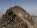
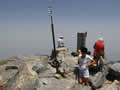
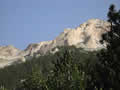
Mytikas - the mount of gods
The Greeks thought of it as built with crystal mansions wherein the gods, such as Zeus, dwelt. It is also known in Greek mythology that when Gaia gave birth to the Titans they used the mountains in Greece as their thrones since they were so huge, and Cronus sat on Mount Olympus itself. The etymology and meaning of Olympus is unknown, and it may be of Pre-Indo-European origin.
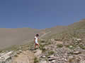
 From the sea coast to the top of mt. Olympus
Kilian Jornet, broke a new record run to the summit of Mount Olympus and descending from mythical mountain, with a time of 5:19:45 h. The route was 45 kilometers long, with over 2.800 meters upward slope in the first 22,6 km, a total upward slope of 3,508 meters and a total downward slop of 3,228 meters. Ok,
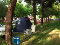
You do not need to run on Mount Olympus, just take a hike and enjoy a trip.The origin of the trip is a coast under Mont Olympus.There are many camps , villas or hotels in Leptokarya, Platamonas or Paralia hotels where you can stay.We stayed in camp near Plaka. Almost all camps are named Olympus. If you plan a climb to Mount Olympus in springtime or autumn, then you have a lot of chances to find free hotel in Plaka or Paralia whitout reservation.
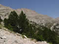
Litochoro, is the last village encountered before the ride to Prionia. The road from Litochoro to Prionia is well signed. The steep switchback mountain road affording tantalizing views into the inner cirque of Mytikas. The only turning off is to the new Dhionisos Monastery. On entering the valley formed by the river Enipeas, steep escarpments are seen, reminiscent of Cheddar George. The road becomes unmetalled from 1700mtrs. The distance from Litochoro to Prionia is about 17 km.
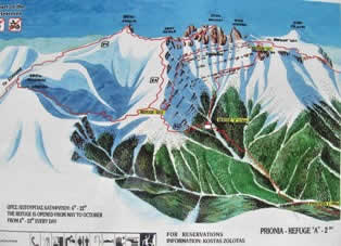
From Prionina to Refuge A Spilios Agapitos (2060)
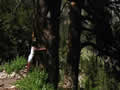
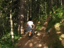
 On the parking place of Prionia village you can live a car. Close the park place is situated wooden caffe bar where you can stay for a moment. This also a starting point from where you must continue climb on foot. The path to the Refuge Spilios Agapitos is well maintained, and the first kilometres of path is suitable also for casual walkers. The path initially follows the valley of the upper river Enipeas , which is in summer time completely dry. There is evidence that the river was active at other times of the year. The forest comprise of deciduous Beech, and created a nice shade from the heat. The downside was the flies/midges that frequented the woods. In the main the path leads upward, and occasionally crosses the riverbed.
From Prionia to the Refuge "A" under Mount Olympus you need 2:30 - 3:30. Do not forget to take enough
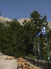
of water. The refuge is situated on an impressive Buff. It is very clean presentable refuge providing food if required for both residential or visitors alike. It is open Sunday to Friday, closed on Saturday.
From Refuge A to the top of mt. Olympus
Refuge "A" Spilios Agapitos (2060 m), Skolio (2904), Mytikas (2918m)
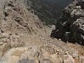
Dont forget fill up water (again) and before continue trip check the weather report. The path from the refuge follows a steep ridge (Chondromesorachi), by zigzagging upwards through scrubby trees. At 2500 m the metal yellow flag indicating the path to Refuge C, and onwards to Skala/Skolio. The path now crosses westwards to the summit of Skolio. From the ridge of Skala is visible the full extent of the west face of Skala, Mytikas, Stefani and the valley of Xerolaki.
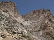
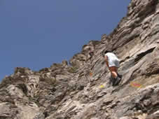
Climb from Skala to Mytikas
Skala (2880 m) - Mytikas (2918 m)The climb from Prionia to Skolio and Skala is suitable for hikers in a good shape. The ascent from Skala to the summit of Mytikas is pretty pretentious and suitable for hikers without dizziness. The route begins with initial gully descent and continue with crossing of scramling slopes under mountain crest between Skala and Mytikas. The last part begins in the foothil of Mytikas with couloir and stepped slabs. There is no special climbing difficulty, except attention because of the risk of rocks falling. The Summit of Mytikas you reach in a few minutes. From refuge "A" to the summit of Mytikas: 2:30 - 3:00 houres.
 Return via Louki Couloir
Mytikas - Louki Couloir - Refuge A.The terrain with tall yellow conical towers on the East side looks like mountain in Dolomites. Descent through Louki Couloir is not difficult - attention on . The route after 30 minutes reach main path wich crosses Mytikas from Refuge C to the Muses plateau. The path is avalanche prone in the winter and early spring. Climb Difficulty: The routh to the Scolio and Skala is appropriate for all hikers. Ascent to the Mytikas require mountainers with experience. The trip last out one long day.
Gear: A pair of good shues, trekking poles, water, a hat and sunscreen, helmet because of the risk of rocks falling in last part of route.